Stonehenge stone circle, near Amesbury, Wiltshire, England
Stonehenge
Nearest Town: Amesbury
County: Wiltshire
Country: United Kingdom
51N10.712′ lat.
1W49.516’ long.
Elevation: 331 ft.
Stonehenge is the most famous megalithic site in the world. For generations, this assemblage of standing stones and lintels has fascinated, perplexed, and drawn millions of visitors each year. Thanks to an agreement between English Heritage, archaeologists, Pagans, Druidic orders, New Age Travelers, tourists, and revelers, it is now possible for thousands to walk amidst the stones from dusk till dawn on the summer solstice and witness sunrise over the great megalithic “Heel Stone” on the northeast horizon.
Stonehenge has been interpreted in many ways throughout the centuries: for example, as the foremost symbol of Britain’s prehistoric past; as evidence for a sophisticated lost civilization; as proof of human contact with an extraterrestrial race of aliens; and as the site where a traditional way of life fought to maintain itself against new societal visions. Because Stonehenge is a prehistoric monument, most of what we think we know about it (which is very little) comes from new archaeological discoveries and changing intellectual fashions in the fields of anthropology, archaeology, history, and religious studies. Each generation creates its own vision and representation of Stonehenge, and these visions often tell us more about the viewers and thinkers than about the place itself. As things stand in the present moment, Stonehenge is caught in a thicket of contending astronomical and archaeological interpretations, ranging from the plausible—a site for ancestor rites celebrated on the solstices—to the fantastic—a healing center built by colonists from Atlantis. As for the many astronomical interpretations of the stone circle, including those made popular by C. A. Newham, Gerald Hawkins, and Fred Hoyle, most archaeologists are in tacit agreement with archaeologist Clive Ruggles who asserts there is no persuasive evidence that the builders of Stonehenge incorporated precise astronomical alignments into their building plan. Moreover, he disputes that the site was used to predict eclipses, meteor showers, or that it functioned as a prehistoric observatory or computer. At the same time, he and other archaeologists acknowledge that the site’s axis does have a relationship to significant solar and lunar cycles, and that the builders of the henges paid attention to the symbolism of celestial phenomena
The folklore surrounding Stonehenge is rich and varied. One legend asserts that when water comes into contact with the stones it acquires healing powers. Another says that the bluestones of Stonehenge originated in Africa but were brought to Ireland by giants in the distant past. From there the magician Merlin worked his art and transported them to Salisbury Plain.
For most of its lifespan, Stonehenge has been in a state of ongoing deterioration; only in the past century have public efforts been focused on preservation and conservation. Most of the sarsen uprights are now encased in concrete foundations, having been straightened (when leaning and in danger of falling) or re-erected from their fallen position on the ground. Nearly half of the original megaliths are either missing entirely or hidden under the turf in broken pieces.
The name “Stonehenge” comes from Saxon linguistic roots: ‘stone’ and ‘henge’ or ‘hang.’ Literally this meant a place of hanging stones, or a place with uprights and lintels linking them.
A visit to Stonehenge brings one to an entire complex of megalithic monuments. There are large numbers of long barrows, round barrows, and henge monuments in the immediate vicinity, and many of these are visible as one scans the surrounding horizon from Stonehenge itself. Thus Stonehenge lies at the center of a ceremonial and funerary district that was in active use beginning as far back as 8000 bce and continuing, with some long breaks, into the present era.
Description
Stonehenge is located in Wiltshire, a district of south central England. The site is about 30 miles North of the English Channel and 80 miles West of London. It sits 330 feet above sea level, on rolling chalk downland commonly known as “Salisbury Plain.” The nearest town, Amesbury, lies 2 ½ miles East in the valley of the Avon River; the city of Salisbury lies 8 miles to the South.
As one enters the site via the underground passageway leading from the interpretive center, the first features visible are earthworks. These include an inner circular bank, an outer ditch, and a slight outer bank. The inner diameter of the inner bank is about 330 feet. Because of erosion and silt buildup the ditch’s bottom is now only 3 feet below the top of the bank. Circular henges of this type do exist in the British Isles, with the closest match to Stonehenge’s shape found in the Orkney Islands off Northern Scotland, the Ring of Brodgar. Two large blocks called ‘Station Stones’ lie opposite each other just inside the northwest and southeast sides of the bank. It is possible two other station stones (at the southwest and northeast) completed a rectangle straddling the circle. Also just inside the bank are two small ditches, called the north and south ‘barrows,’ and 56 Aubrey Holes, a ring of evenly spaced pits which likely contained 4 m high wooden poles in the distant past. The holes on the eastern side are marked with round concrete markers set into the turf. Invisible but present beneath the turf are two more rings of holes, the Y and Z holes, which lie outside the first stone ring. Each of these rings has thirty holes, which corresponds with the original number of upright megaliths in the outer circle.
On the northeast side there is a 35-foot wide causeway that cuts through the bank and ditch. The causeway connects to the “Avenue,” two parallel banks and ditches roughly 70 feet apart that run down the sloping hill to the northeast. The Avenue is best viewed from the air, since the field is covered in grass for much of the year. Along the Avenue, just before it crosses the main road to the site, sits the Heel Stone, a slab of rough sarsen surrounded by a little ditch and pointing inward to the monument. Sarsen is a hard sedimentary stone than is present in patches throughout south and east England, but especially in north central Wiltshire. It typically lies in large slabs just above or below ground level. The Heel Stone weighs about 35 tons and rises 16 feet (4.5m) high. The sun on the summer solstice rises across this massive sarsen when viewed from inside the megaliths. At the point where the causeway crosses the inner bank is a rough-dressed sarsen lying flat on the turf and measuring about 21 ft x 7ft. Its upper surface is heavily pocked with bumps and hollows that fill with rainwater. During the 18th century, observers named this 28-ton behemoth the ‘Slaughter Stone’ and decided it had been used to catch the blood from ritual sacrifices. A second causeway cuts through the ditch and bank at the South end of the circle; other breaks in the bank were created in modern times.
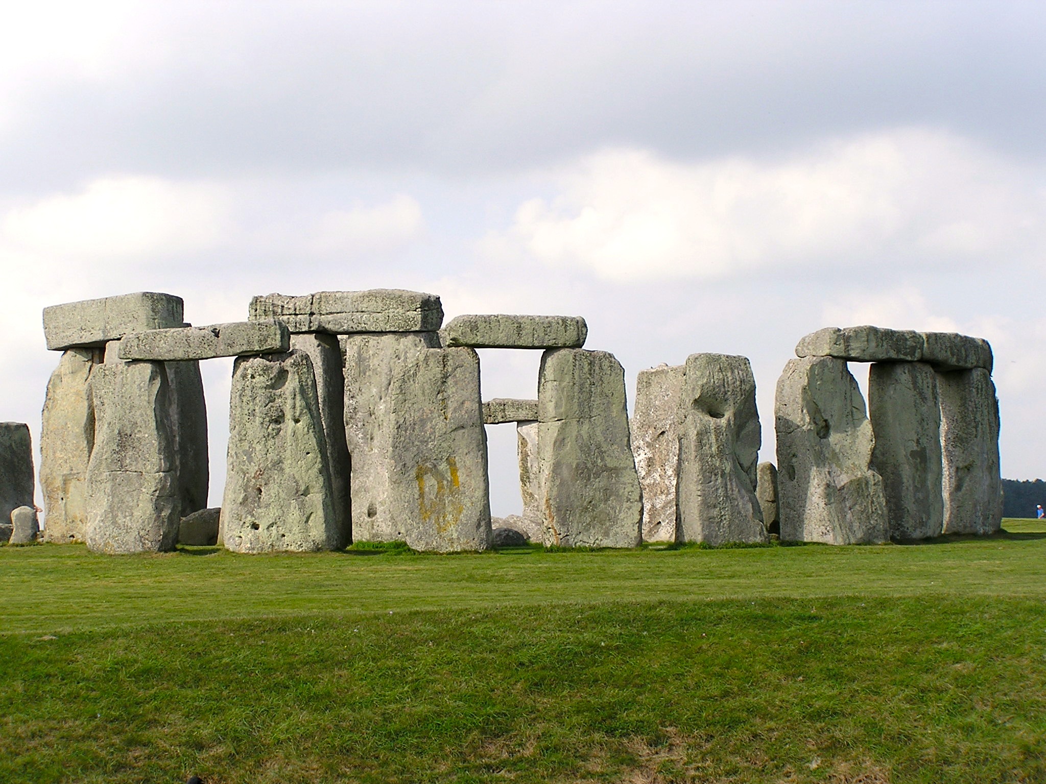
The structure at the center of Stonehenge is made of orange-brown and bluish stones now covered by a close overcoat of grey-green lichens. The outer ring of 17 standing and 8 fallen sarsens (originally 30) is arranged in a true circle measuring 100 feet in diameter. Each of the outer stones rises about 13 ½ feet above the ground, is nearly 7 feet wide, and has an average thickness of 3 ¾ feet. All but one of these megaliths weighs over 26 tons. The stones are separated one from another by a gap of about 3 ½ feet, and the inner face of each stone is smoother than the outer face. Stone number 4 due east of center has a number of axe carvings on its surface. One of the most unique features of Stonehenge is the setting of horizontal stone lintels atop these massive uprights. About half of the original 30 lintels can be seen today. When first constructed, they formed a continuous circle 16 feet above the ground that linked the uprights one to another. The lintels are 10 ½ ft long, 3 ½ feet wide, about 2 ¾ feet thick, and weigh 7 tons each. Using a technique from wood carpentry, each lintel has two hollows on its underside which fit into two cones projecting from the top of the uprights; mortice and tenon technique. The lintels are secured to each other by a vertical tongue at one end that fits snugly into a corresponding groove on the adjacent neighbor; standard tongue and groove technique. Each lintel has a slight curve on its interior and exterior faces so that the appearance of a smooth circle is created. All of these structures are joined with no use of mortar. At present the sarsen circle is most intact on its northeast quadrant. There 11 stones remain standing together, and three lintels run continuously across them. Three additional pairs of uprights support single lintels, and two lintels lie fallen on the ground.
The sarsens of this Great Ring are tapered on their upper end with convex curves. This is reminiscent of a technique used in Classical Greek temples, whereby the columns are slightly curved to present the optical illusion of perfect straightness. The two uprights at the northeast side of the circle appear to be set slightly farther apart than the other uprights, perhaps indicating an entryway. The lengths of individual uprights differ, but an illusion of uniform height is maintained by varying depths to which stones are planted in the ground. The lintels are not straight, but curve on both inside and outside faces so they meet in a smooth circle. Although barely visible, trilithon upright 53 has the shape of a dagger carved on its inner side, surrounded by engraved bronze/copper axeheads, with blades facing upwards. By far the most decorated stone is number 4, due east of center, which has multiple carvings of axes, some large, some small. with many axe carvings. Adjacent stones 3 and 5 also have several axe engravings. Stones 2 and 3 have natural grooves on their upper sides that resemble male and female genitalia.
Just inside the Great Ring is the first set of “bluestones,” igneous rocks consisting of rhyolite, dolerite, tuff, and altered calcareous and volcanic ash. It is likely these stones were brought from the Preseli Hills in southwest Wales, a distance of about 300 km. These 6½ ft high uprights have no surmounting lintels and form a slightly irregular circle about 75 feet in diameter. They measure 3¼ to 4½ ft wide and 2½ ft thick. Twenty of these bluestones remain from an original ring of perhaps 60-70 undressed stones; nine stumps are hidden beneath the turf. Six bluestones remain upright, some are fallen, and some lean against each other. Two of these outer bluestones are trimmed and have mortises at each end. They were likely originally used as part of a bluestone trilithon structure, the recycled as simple standing stones in the outer bluestone ring.
Inside the bluestone ring are five sarsen trilithons (a term coined by the 18th century antiquarian William Stukeley; it is Greek for “three stones”) organized as a horseshoe with its open end facing northeast. Each sarsen is dressed with its smoother side facing inwards. The lintels atop the uprights are held in place with tenon-mortise technique similar to that used in the outer ring. Each trilithon stands as an independent structure. Today the visitor sees only 3 pairs of support uprights still erect with lintels intact, although all fifteen stones of the original trilithons are present. These uprights have been set in concrete to ensure their stability. The gaps between linked pairs in the horseshoe are quite thin in comparison with the gaps between the uprights in the outer ring. The trilithons on the north and southwest ends of the horseshoe are damaged; the twin upright for the southwest trilithon has fallen and broken into two pieces. Its 19-ton lintel is also on the ground. The remaining upright stands 7m high and weighs close to 45 tons. It and its fallen twin are the largest of the trilithon pairs and stood facing the solar corridor that includes the Heel Stone to the northeast. The trilithon on the north end of the horseshoe also has one erect upright and one fallen twin and lintel. Each of these is broken into three pieces. Of the three intact trilithons, the pairs nearest the southwest trilithon are the highest, each rising to 5.2 meters. The pairs at the northeast end stand about 5 meters high. These 40-ton uprights support lintels of 16 tons each; the weight of the stones in the outer ring and inner horseshoe totals about 1500 tons. This is megalithic architecture on a truly grand scale.
A horseshoe of 14 dressed bluestones (out of an original set of 19) are found just inside the trilithon horseshoe. The stones at the northeast side are just under 6 feet in height, and the stones at the southwest side rise to about 8 feet. This mimics the rising height of the sarsen uprights in the trilithon horseshoe. These lintel-less dolerite stones have been carved in the shape of rectangular posts. Lying on the ground at the horseshoe’s apex is the so-called Altar Stone, a six-ton bluestone composed of green micaceous sandstone. It is split in two and mostly hidden beneath pieces of the massive sarsen at the southwest side of the horseshoe. This largest of the bluestones measures 4.9 m long and is flecked with glistening mica.
Background and Origins:
The origins of Stonehenge go back to the period just after the last Ice Age in England, to around 9000 bce. Prior to this, from 23,000 to 10,000 bce, England was too cold and glaciated for any significant human habitation. As temperatures warmed around 10,000 bce, forests of pine and birch, then oak and hazel appeared, and migrations of people began in substantial numbers. These people lived by hunting, fishing, and gathering. They and natural events such as fires created openings in the forest that in time were enlarged by the first Neolithic farmers. The area around Stonehenge slowly became mature grassland suitable for cattle grazing and plant cultivation. The earliest evidence of human activity near today’s site is 4 or 5 large pits, about 3.2 ft (1m) deep and 6.5 ft (2m) in diameter. Into these pits the inhabitants placed large wooden poles as large as 2.4 ft (.75) in diameter. What they were used for is unknown, but four of the posts were placed in a straight line orientated roughly east-west. Charcoal from the pits indicates the posts were pinewood and set in place between 8500-6700 bce. They may have resembled the free-standing totem poles found among Pacific Northwest Indian tribes, although nothing resembling them has ever been found in Great Britain. These postholes are now clearly marked in white paint in the car park at Stonehenge.
Between 6700 and 4000 bce, there is no evidence of manmade structures or artifacts on the Stonehenge landscape. The first evidence of early Neolithic farming appears at places such as Coneybury, where a pit excavation yielded such artifacts as leaf-shaped arrowheads, flint axes, and pottery, as well as remains of domestic cattle and wheat. Between 4000 and 3000 bce the first long barrows (long burial mounds consisting of chalk excavated from side ditches) appear in Wessex along with Neolithic pottery. The larger of these funerary monuments faced east. In addition a circular monument with two concentric circles of banks and ditches appears at Robin Hood’s Ball. The banks and ditches appear to be divided into sections that resemble strings of sausages with causeway separators. There is some evidence for ceremonial rites on the east end of these henge monuments. Sometime around 3250 bce the population built an elongated avenue 100m wide and 3 kilometers long. This “Cursus” was located a few kilometers south of the circular monument, had two parallel banks and ditches, and was orientated east-west. At its east end was a perpendicular long barrow; at its west end a truncated ‘Lesser Cursus’. Excavated bones at these sites indicate they may have been used for funerary ceremonies. Circular funerary ditches at Max Gate in Dorchester and at Llandegai in north Wales date from this same period. The evidence is clear that even at this early Neolithic date the landscape around Stonehenge was laid out with symbolic ritual structures that appear unrelated to such mundane affairs as procuring food and shelter.
In 1995, after many years of mistaken dating for Stonehenge itself, English Heritage funded a credible chronology for the site. Based on precise radiocarbon testing, they established that around 3000 bce a circular earthwork 360 ft (110 m) in diameter was dug out from a chalk foundation using antler picks and other bone implements. The site was on sloping land about 1 kilometer south of the Cursus, neither the highest or lowest point in the area. The earthwork was a continuous ditch dug in sections with at least 2 causewayed entrances, the largest on the northeast side. An inner and outer bank made from the excavated chalk ringed the ditch. Archaeologists found an ox skull, ox jaws, and the tibia from a red deer near the south causewayed entrance that predated the earthwork monument by some 400 years. These bones may have had some symbolic significance and may have been placed in the newly dug ditch to dramatize continuity with past traditions/values.
Inside the bank 56 evenly spaced holes (commonly called “Aubrey Holes” after their discoverer John Aubrey) were dug at a depth and diameter of 1 meter. The holes likely held 4-meter high wooden poles, creating a ring of timber posts about 287 feet (87m) in diameter enclosed by a bank of white chalk. It is unclear what this monument was used for, but it resembles Woodhenge a few kilometers to the northeast and the Ring of Brodgar in the Orkney Island (except that Brodgar’s ditch and bank enclosed a ring of megaliths).
Between 2900-2550 bce, the ditch begins to fill in due to erosion and possibly deliberate backfill. 24 of the 34 excavated Aubrey Holes show evidence of cremated human bone; other cremation remains have been found in and around the ditch. Clearly there is some kind of funerary function for the site at this time. There also is evidence that irregularly spaced and placed timber posts were set up, sometimes in rows, especially near the northeast and south entrances. What they were used for is unclear, but large earthworks and timber rings appear during this period at Avebury, Durrinton Walls, Coneybury, Mount Pleasant, and Marden. Some archaeologists, including Aubrey Burl and Rodney Castleden, believe the post holes are evidence that some kind of timber building once stood at Stonehenge’s center. Mike Pitts disagrees, positing instead the existence of funerary posts upon which bones or offerings hung.
In the period beginning around 2550 and lasting to 1600 bce there is a switch in construction material from wood to stone and the appearance of the massive megalithic structure we most clearly associate with Stonehenge today. This construction cycle took place in phases that are not always clearly understood, given the many haphazard excavations and rabbit burrow damage that have skewed the physical evidence beneath the turf. Europeans had been using stone tools for at least ½ million years by this point, and they had a mature understanding of fracture mechanics, and grinding, polishing, and drilling technology.
Archaeological excavation by Richard Atkinson revealed that a double bluestone structure might have been the first monument built at the site. There is some evidence it may have had a rectangular shape with openings to the southwest. Also at this time, the bluestone Altar Stone was set up on an axis that corresponded with sunset on the winter solstice and sunrise on the summer solstice. Where did the bluestones come from? Despite the contentions of a team from the Open University in Milton Keynes that bluestones were deposited in the Stonehenge districts by ancient glaciers, analysis of river gravels in Wiltshire by Christopher Green showed conclusively that glaciers never reached these waterways and thus cannot be used to explain the presence of Welsh bluestones on the Wiltshire chalk uplands. The bluestones most likely originated in the Preseli Hills in southwest Wales. How they were brought to Stonehenge remains a mystery, although some combination of overland dragging and passage by boat seems likely. Richard Atkinson speculated that the stones were brought overland from the Preseli Hills to Bristol Channel, and then brought by boat to Stonehenge using a route along the Somerset Avon, the River Wylye, and the Wiltshire Avon. This route necessitated a small portage between the rivers Avon and Wylye.
During this early phase two sarsens were set up along the site’s main axis outside the ditch on the northeast side. The one that remains today is the Heel Stone, and it was sited so that the summer solstice sunrise appeared to move over its top when viewed from the center of the circle. The other sarsen was removed after a short time and the ditch around the Heelstone was dug. Just inside the northeast causeway three sarsens were erected, including the only stone remaining today, the Slaughter Stone. Finally, the four sarsen Station Stones were laid in place just inside the bank. The only pair that remains today is the pair at the west and east ends of the Great Circle. The two others were erected on mounds that had encircling ditches. The Avenue was also constructed during this time. This bank and ditch path ran from the site down into a small valley for about ½ kilometer, then curved eastward for 2.5 kilometers until it reached the Avon River. The Avenue allowed for processions that came along the site’s main axis and entered the circle from the northeast.
After parts of this original structure were destroyed, the sarsen circle measuring about 98 feet (30m) in diameter and the trilithon horseshoe was built between 2300-2400 bce. The sarsens were quarried on the Marborough Downs some 30 miles north and dragged to Salisbury Plain using wooden rollers. The last part of the sarsens’ journey likely came along the Avenue, which archaeologists believe was finished by this time. Thirty sarsen uprights supported 30 lintels in a tight geometrical shape that constituted the Great Circle. The evenly-spaced gaps between the stones were smaller than the width of each individual stone. Before levering the uprights into place, the builders had to dig deep pits with stone hammers and mauls and dress the visible parts of the sarsens. To ensure that the tops of the uprights were level, some stones had to be propped up with rubble and some pits had to be dug deeper. Mortise and tenon joints stabilized the lintels on their uprights, and tongue and groove technique fit them snugly one to another. Each sarsen’s smoother side faced inwards. Christopher Chippendale is not convinced the full circle was ever completed, and speculates that the builders ran out of uprights and never completed the ideal design.
Inside the circle the builders constructed the trilithon horseshoe, with 2 sarsen uprights supporting a lintel in 5 free-standing structures. This monument rose from its open northeast side to the highest trilithon at its southwest end. It fit exactly along the site’s old axis orientated to the two solstices. These sarsens, like those of the Great Circle, were finely shaped with their smoother sides facing inwards.
Around 2100 bce a bluestone circle of somewhere between 60 and 80 undressed uprights was constructed 2.5m inside the Great Circle. Two of the stones appear to have been reused lintels from an earlier bluestone structure within the trilithon horseshoe. The uprights were well-spaced and lintel-less. At the same time an oval of about 23 dressed bluestones appeared inside the trilithon horseshoe. The Altar Stone reappeared at the oval’s northeastern apex. Around 1900 bce some stones were removed from the northeast side of the bluestone oval, leaving a bluestone horseshoe that mimicked the shape of the sarsen trilithons.
In Stonehenge’s final phase of construction (ca. 1600 bce), two concentric rings, the so-called Y and Z holes that surround the main stone monument, were excavated. There are 29 holes in the first ring, and thirty in the outermost ring, strongly suggesting a relationship with the lintels and uprights of the Great Circle. It is unknown why these empty holes were dug or what ritual function they might have served. The carvings of flat axes on the upright sarsens mentioned earlier also appear at this time. Little documented activity occurred at Stonehenge after 1500 bce. There is some evidence for Romano-British habitation in the area, and some polished axe fragments, a stone mace-head, a ceramic disc, a copper bead, and a copper-alloy awl from later Bronze and Iron Age periods.
What was Stonehenge used for? Archaeologist Mike Pitts comments that stone’s durability and solidity make it a potent symbol for the timeless and immortal ancestors; certainly it is a clear contrast with the perishable nature of wood, which he thinks is a better symbol for the living and the recently deceased. In places such as Madagascar, wood structures have associations with the newly dead while stones are connected to those who have long ago made the arduous journey to the next world. The natives of the southern part of the island erect carved wooden poles to commemorate recently deceased individuals. Bones of the long departed are moved to common stone tombs that symbolize collective ancestry. In a leap that many archaeologists are hesitant to make, Pitts notes that ancestral rites are a common feature of kinship-based societies and thus that it is possible that a kinship-based society like Neolithic Britain might have had a similar understanding of wood and stone.
On Salisbury Plain, Stonehenge is the principal stone structure. Woodhenge and Durrington Walls were constructed mostly of wooden posts. In addition, remains of domesticated pigs dominate the finds at Durrington Walls and Woodhenge, while the remains of cattle and wild animals like boar and aurochs are found at Stonehenge. Did the living prefer domestic swine, which had larger and more frequent litters? Did the ancestors prefer beef and the flesh of wild mature animals?
Using these ruminations, Pitts has advanced a vision of what took place at Stonehenge at the peak of its importance. In Hengeworld, Pitts lays out the following ritual event, which would have been repeated through many generations. Pitts saw the complex of henge monuments at and around Stonehenge as part of an elaborate ritual system focused on the domain of the living, the domain of the dead, and the passage between these two realms for the recently deceased. Ceremonies began at a henge monument at Durrington Walls, about 2 miles north of Stonehenge. The celebration of the living took place here during the summer solstice with feasting, sacrifices (of pigs), drumming, and chanting inside a huge ditch and its surrounding bank. The bank was covered with white quartz, giving the the ritual space a gleaming, sparkling aura. During the celebration, the corpse of a newly deceased tribal member was brought to the site and prepared for its journey to the domain of the dead.
At the right moment, the participants left Durrington Walls and entered Woodhenge, an adjacent henge monument that represented the domain of unification. The deceased tribal member was taken around a circuit of standing stones and wood memorial posts, which represented guardian spirits who would protect the newly deceased during their dangerous journey to the land of the ancestors. Pitts believes that Neolithic peoples understood East to be the direction of life and West the direction of the afterlife and world of the ancestors. This explains the presence of the bluestones at Stonehenge. These stones came from the West, the Preseli Mountains in Wales, and made their journey from Wales to Salisbury Plain via the Bristol Channel and the river Avon. In a similar manner, the newly deceased made a journey from the West (Woodhenge) to the East, the Avon river, and thence South to Stonehenge itself, where they were reunited with the bluestones (ancestors) in the domain of the dead. The winding route south along the Avon was designed to disorient the spirit of the deceased, so it could not return to the domain of the living to cause trouble.
Near present day Amesbury, the procession left the Avon and took the corpse (or its bone remains) along the Avenue moving northwest for one kilometer, then West, curving for half a kilometer toward a ridge, down a hill for 750 meters, then abruptly turning southwest where it climbed for about half a kilometer to Stonehenge itself. The Avenue was a simple earthwork with two parallel banks (probably covered in white quartz rocks) and flanking quarry ditches. The procession entered the ancestor’s symbolic home, Stonehenge Great Circle, via a gap in the surrounding earthwork, and progressed around the circle paying respects to the 30 sentinel guardian stones around the periphery. As it moved to the center of the monument, it passed the five pairs of trilithons. The first of each pair was more finely dressed than its twin, and the structure likely symbolized the joining of the newly dead with the ancestors. The circular form of the Great Circle represented the unending cycle of life and death, the thirty stones the constant monthly lunar cycle. Only twice during the year did this cycle pause, at the summer and winter solstices. At these cardinal points of the annual solar cycle, the points on the horizon where sunrise and sunset occur reach their closest arc. The living (sunrise) and the dead (sunset) can communicate and pass into each other’s realm. As the midsummer sun rose along the Avenue, over the Heelstone, and struck the Altar Stone at the end of the inner horseshoe of five trilithons, the newly dead experienced their final passage into the timeless domain of the ancestors. The same opportunity occurred as the sun set on the winter solstice. Pitts concludes that some form of altered states of awareness was likely involved in these ceremonies, whether induced by mushrooms, fasting, dancing, chanting, or some other means. In addition, he speculates that the complex of funerary monuments around Stonehenge would have involved the efforts of large groups of people, far more than lived in the immediate district. For people who lived a partly mobile existence and settled only temporarily to cultivate and harvest as the seasons dictated, Stonehenge would have been a sacred site where the immortal ancestors lived a settled existence. Thus Stonehenge was sacred funerary space where people from throughout southern England gathered on a seasonal basis. And unlike older monuments like the West Kennit Long Barrow near Avebury, where disarticulated skeletons, with some parts removed, were buried together in covered antechambers, at Stonehenge odd human bones and cremations were scattered around the site. It was more a symbolic world of the ancestors and ritual site than a mausoleum for particular families or personages.
History of Archaeological Excavations:
The archaeology of Stonehenge is a fascinating story of eccentric antiquarians, plodding excavators, changing intellectual fashions, and a great deal of speculation based on very thin evidence. Ideally, archaeology is able to create a plausible chronology based on plainly evident layers that overlie each other and verify one era’s relationship to another. The evidence at Stonehenge is too shallow and spread out to create certain chronologies; the interpretation of the site has required speculative links between distinct elements that logically seem to fit together, but that often lack the physical evidence to make an airtight case for precise dating.
William Cunnington, a trader, and the baronet-banker Richard Colt Hoare undertook the earliest formal excavations at Stonehenge between 1801-10. Their interest lay mainly with the many round barrows in the Stonehenge district and in excavating under the Slaughter Stone to determine whether it had originally been an upright. The Antrobus family took care of the site between 1824 and 1915, when Cecil Chubb bought it. He donated it to the nation of Great Britain in 1918. Since then stewardship for Stonehenge has been held by, in succession, the Office of Works to the Ministry of Works, the Department of the Environment, and (currently) English Heritage.
During the 1800s, a Captain Beamish was allowed to excavate near the Altar Stone (around 1839) in order to disprove burials in the center of the monument. His excavation six feet into the ground in an area 8 feet square yielded nothing but rabbit bone. Charles Darwin was granted permission to conduct digs around fallen uprights as part of a larger investigation into the cumulate effect of earthworms on the disappearance under the turf of ancient buildings.
The next excavations took place in August and September of 1901, when Sir Edmund Antrobus granted William Gowland permission to dig around the base of an upright that was being restored on a concrete base. At a superficial level Gowland found bottles, buttons, pins, and other artifacts that were unrelated to Stonehenge’s builders. Deeper down he found sarsen and bluestone fragments and the 2 meter pit that had been dug in the chalk to place the upright. The discovery of a deer antler embedded in the chalk led him to conclude the pit had been dug using these antlers. Gowland unearthed over 100 stone tools that had been used to dress the sarsen uprights. He concluded, based on fragment counts, that the bluestones had been dressed onsite while the sarsens had been roughly dressed where they were quarried and only lightly finished on site. His conclusion that Stonehenge had been built in the Late Neolithic as a shrine to sun worship still has its supporters after more than 500 trench excavations. The major mistake in Gowland’s findings was his claim that the monument had been built at one time, rather than over a number of generations. This claim has now been decisively disproven (see background and early history).
The next archaeologist to work at the site, Lieutenant Colonel William Hawley, excavated Stonehenge between 1919-1926 under the auspices of The Society of Antiquaries. Using winches, steel ropes, and jacks, Hawley and a team of workers straightened leaning megaliths and dug out foundations in 1919. Working with Robert Newall, he then located and dug out 23 Aubrey holes, discovered the Y and Z holes, and excavated many postholes and human remains, both unburned and cremated. In later years Hawley excavated the part of the Avenue that led to the circle, half of the surrounding ditch, and part of the ditch that surrounded the Heelstone. His discovery that a layer of bluestone and sarsen chips (the “Stonehenge layer”) overlay the silt covering the bottom of the ditch led him to confirm Sir Flinders Petrie’s view that the bank and ditch earthwork predated the stone monument.
Hawley was the first to propose that Stonehenge was constructed during three periods. This view has been refined by later archaeologists such as Richard Atkinson (1956), Aubrey Burl (1995), and Mike Pitts (2000). Using Pitts’ chronology, Phase 1 occurs between 2950 and 2900 bce. During this phase the main inner bank and ditch are dug and the Aubrey Holes are excavated. Phase 2 occurs between 2900 and 2500 bce. It is at this time that the smaller outer bank is dug and various posts are dug in the southern passage, the center, and the northeast causeway. Both the ditch and the Aubrey Holes are used for cremation burials. Phase 3 spans a period between 2500 and 1600 bce. During this time the Heelstone and its twin are erected, the Heelstone ditch is dug, the Station Stones and “Barrows” appear, and the Avenue ditches and banks are excavated. In the interior of the circle the Sarsen Circle and Trilithons, and the bluestone circle and horseshoe are erected. Finally, the Y and Z Holes are dug. In Hawley’s view, the monument began as a defensive dwelling and later evolved into a religious ritual site. This conflicted somewhat with Petrie’s (1904) opinion, that Stonehenge was a place for public worship, civic meetings, and interment of the dead. By 1926, Hawley had excavated almost half of Stonehenge, a feat never since approached. Although his work has been heavily criticized by later archaeologists, he left an impressive collection of notes, drawings, photos, and publications on the site.
The next major phase of archeological exploration took place beginning in 1950 with the appointment of Richard Atkinson, Stuart Piggott, and Marcus Stone by the Society of Antiquaries to further excavate Stonehenge. They dug small areas near the bank and ditch entrance and around some of the bluestones. Their discovery of a woman’s cremated remains was found to be similar to those of other cremation burials in nearby round barrows from the same era. Pitts estimates that the cremated remains of 240 people were buried in the area around the bank and ditch between 3000 b.c.e. and 2300 b.c.e. He paints a scene of funeral pyres, rites of mourning, and expressions of grief on the part of family members. By the time the Y and Z holes (which Pitts believes are graves) are dug, Stonehenge has become part of a funerary system that includes circular mound burials throughout Wessex. In these graves are human skeletons, and cremated remains buried with copper and bronze daggers, incense cups, and gold, amber, and jet jewelry. Pitts now sees Stonehenge as a symbolic grave, with corpses represented by the distinctive carvings of axes and daggers that appear at this time. He speculates that what had been a monument to the ancestors is now a burial mound dedicated to a god-like man and his retinue. The man’s tomb is surrounded by two rings of graves (the Y and Z Holes), and, in the distance, by two bands of barrows. He has now become the focus of a cult of hero worship. Stonehenge is his personal memorial and no longer the place where the recently deceased were brought together with their ancestors.
It is Atkinson and Piggot who speculated that the “architect” of Stonehenge was not a Northern European barbarian. To account for the monument’s unique architecture and design it was necessary to consider contemporary European cultures with a living tradition of monumental architecture. In Atkinson’s view, this culture could only be Greece. Today, based on comparisons to various wood henges and superhenge earthworks in Great Britain, it has become accepted that Stonehenge is not exotic or unparalleled but rather an indigenous construction of a piece with other similar henge works of the period.
Bibliography:
A Guide to the Stone Circles of Britain, Ireland, and Brittany. Aubrey Burl. New Haven: Yale University Press, 1995.
Circles of Stone: The Prehistoric Rings of Britain and Ireland. Aubrey Burl. London: The Harvill Press, 1999.
Facing the Ocean: The Atlantic and its Peoples. Barry Cunliffe. Oxford: Oxford University Press, 2001.
Hengeworld. Mike Pitts. London: Arrow Books, 2001.
Megalithic Mysteries. Michael Balfour. London: Parkgate Books, 1992.
Stonehenge Complete. Christopher Chippendale. London: Thames and Hudson, 2004.
Pingback: Stonehenge (England) - Famous Ring Of Massive Stones With A History of Over 10,000 Years! - EatandTravelWithUs