Skip to content
NOWCAST KCCI News at 8am Saturday Morning
Watch on Demand
Advertisement

Storm Team 8 In-Depth: Basic cloud observation and interpretation

Storm Team 8 In-Depth: Basic cloud observation and interpretation
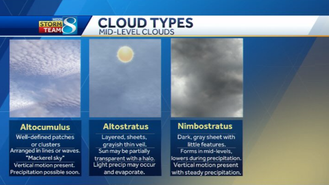
thanks for logging on the K. C. C. I. Dot com. I'm meteorologist tray Fulbright and today in this storm team eight and death we're gonna talk about cloud observation behind me right now you're looking at our visible satellite imagery. This is what we use to detect clouds and watch cloud features. We can see we see show this on air quite often but typically with visible satellite that's something we use during the day to detect clouds as we rely on sunlight. At NYU we look at other imagery is here of satellite that will help us out to detect clouds. So today we're gonna talk about cloud classification and basic cloud observation. When we talk about clouds we can classify them by height and appearance And when we talk about height for us in the mid latitudes where we are and central Iowa we have low level clouds which are below 6500 ft, mid level clouds which run up to 23,000 ft. And then high level clouds which are greater than 16,500 ft. Now between that 39,000 there's kind of *** mixed range there, there's *** little bit of *** wiggle room there for that mid and high level cloud classification. Now we do have four different categories for cloud appearance. We have zero strata, cumulus and nimbus o. And basically with these these are types of clouds that can form, we're looking at the appearance of the clouds. So we talk about serious clouds. We're talking about thin and wispy clouds stratus clouds are typically ones that are lower to the ground and layered cumulus clouds over ones that have the billowing appearance kind of *** global er mass look to it and then finally nimble clouds or clouds that are associated with precipitation. So these are our high level clouds. Within each of those four categories, we have subcategories as well. So when we look at high level clouds, we have serious clouds which are clouds that we often see when uh we have blow off from precipitating clouds downstream. These serious clouds are made up of ice crystals and they have *** thin wispy appearance. So if you took the, take *** cotton ball and stretch it out, that's what you get kind of *** thin serious that's the thin cirrus clouds. And there's also an increase and this also indicates the potential for *** changing weather pattern. Obviously with the precipitation, the clouds blowing downstream from those precipitating clouds, that's often *** sign that there's *** change in the weather pattern on the way. Then we have cereal strata clouds which are typically more layered in sheets, they still have, they still allow *** little bit of sunlight to come through. But that son may be transparent and with these clouds, since they're made up of ice crystals, you can get *** halo two sometimes form around the ring around the edge of the sun as the light is bent through those ice crystals and then these often precede of warm front or steady precipitation as well. Then we have zero cumulus clouds. These are not often as seen as the other two up here, but they are typically indicative of vertical motion and *** *** lot of instability high aloft in the atmosphere. So next up here we have our mid level clouds. These are alto cumulus here over on the far left. Uh These are often company or they often form and patches or clusters. They're arranged in lines or waves and they look like scales. If you look at *** fish, the back of the fish and think of these clouds, that's one of the good ways to associate those. And these often indicate that there's vertical motion in the atmosphere and that precipitation maybe on the ways you're starting to get more rising motion in the mid levels and moisture working its way in as well. Then we have alto stratus and that's basically Siro stratus, but at *** lower level within the atmosphere. Again, these are layered in sheets with *** grayish thin veil and then the sun may be partially transparent with these as well. One thing with Alto stratus is that you may see some light precipitation fall, but these are these this precipitation is typically falling into *** dry low, the level of the atmosphere so that's gonna end up evaporating on down forming virga and then finally we have nimbus stratus which this is just *** dark layered sheet, those those gray, dreary days When you get rainfall you get precipitation from these. But typically the precipitation from nimbus stratus is not necessarily very heavy as there's some vertical motion but it's not the vertical motion like you would see in *** big towering thunderstorm. Now we have our low clouds here. This is stratus and fog here Over on the left, fog is basically *** stratus cloud that forms near the ground. And with stratus and low clouds like this fog that usually ends up being *** hazard for aircraft and motorists, there's usually very little mixing and weak vertical motion. Typically if you're gonna see these clouds, you're gonna find it and during the early morning hours, especially that fog. And then sometimes you may get *** little bit of drizzle or very light precipitation from these. But again without that vertical motion, you're not gonna get heavy precipitation Next here on this, in the middle column here we have strata cumulus which these are forming and layers or patches as well, they form and roles, they're not as well defined as our cumulus here on the left. But these often appear with temperature infection. So if you have *** cold air mass moving in or *** warm moist air mass moving in, that's one sign that you'll note there when you see that when you see those strata cumulus. And then finally here we have our cumulus clouds. These appear like piles or heaps, those cotton balls, those classic cotton ball appearance, they form on very warm days, especially during the summer. And then these can tower in the thunderstorms if the atmosphere is unstable, but if not, then you just end up with fair weather cumulus. And then finally here when accumulate on *** cumulus cloud towers up into *** thunderstorm, you end up with *** cumulonimbus cloud that's usually going to be the type with rigid billowing edges and then has that atomic bomb look to it, especially if there's *** very powerful thunderstorm indicative of *** strong updraft. And sometimes these can even produce severe weather. So I'm storm teammate meteorologist tray Fulbright. That's going to wrap up our discussion on cloud types today and we'll be doing more of these discussions later on. Thanks for logging on to k c C i dot com.
Advertisement
Storm Team 8 In-Depth: Basic cloud observation and interpretation
If you’ve paid any attention to the skies, you’ve probably noticed different cloud types at different times of the day and different times of year.Clouds offer insight as to what processes are occurring in the atmosphere and how these processes may determine the type of weather you experience. A casual observer can make a nowcast or even a short-term forecast by recognizing cloud types and understanding what they mean. Clouds are classified by their appearance and the height in the atmosphere they form.When classifying clouds by height, the following categories exist: low, mid, and high level. According to the National Weather Service Jet Stream School, low-level clouds in our part of the world, the mid-latitudes, form at or below 6,500 feet. Mid-level clouds form between 6,500 feet and 23,000 feet. High-level clouds form above 16,500 feet.Note that there is some general overlap in the heights of mid and high-level clouds. There may be variations in the height of the cloud bases on a given day or time of year depending on the amount of available moisture and the average layer temperature of the atmosphere. The categories for cloud appearances include: cirro-form, strata-form, cumulo-form, and nimbo-form. Within these four main categories, there are subcategories as some clouds can take on multiple forms depending on which height they form. Cirro-form clouds are made up of ice crystals; therefore, they are found at high levels in the atmosphere where the environmental temperature is bitterly cold. They often appear thin and wispy like strands of hair or cotton pulled apart.Cirro-form clouds often indicate a change in the weather pattern is near because they are associated with the tops or “blow-off” of the vertical development associated with precipitating clouds. Cirrus clouds can often be left behind after the dissipation of a thunderstorm, which can make for spectacular scenes for those interested in landscape photography. The most common subcategories for cirro-form clouds are cirrus, cirrostratus, and cirrocumulus. Strata-form clouds are usually dark, come in layers, and can appear in low, mid, and high levels of the atmosphere. When these clouds form in the low levels, they are either called stratus or stratocumulus. Another form of stratus that we often encounter is fog. This type of stratus forms at or extremely close to ground levels when there is little mixing of the air or warm air mass moves in atop low-level colder air.Mid-level stratus is referred to as altostratus while high-level stratus is called cirrostratus. Stratus clouds are an indication of a cool and moist atmosphere with weak or very little rising motion. Since there is little rising motion often associated with strata-form clouds, they often produce very light and steady amounts of precipitationCumulo-form clouds often appear globular and in masses, piles or heaps. They can range in appearance from looking like puffy cotton balls, to rigid cauliflower, or like the mushroom cloud from an atomic bomb. Cumulo-form clouds give an indication of instability present in the atmosphere which can try to correct balance out via rising motion and the release of heat energy.Cumulo-form clouds that originate in the low levels are called stratocumulus, cumulus, or cumulonimbus. Mid-level cumulo-form clouds are referred to as altocumulus, and high-level cumulo-form are cirrocumulus. Stratocumulus often appears when an air mass of different characteristics is transported into an area (assuming this causes some vertical motion and sufficient moisture is available). Cumulus clouds often form on warm or hot, sunny days when air parcels rise, cool, and condense into little heaps with flat bases. These are referred to as “fair weather” cumulus. Cumulus clouds can eventually tower into cumulonimbus—thunderstorm clouds—as long as the atmosphere is unstable and supports rising motion, and the cumulus cloud doesn’t ingest too much dry air into it.The last cloud categorization is the nimbo-form which essentially means a type of cloud that is precipitating. Subcategories of this group are cumulonimbus — a low level cloud—and nimbostratus a mid-level cloud. Nimbus clouds are usually associated with steady precipitation and some vertical motion, but not the type associated with big thunderstorms.Cumulonimbus are often referred to as “thunderheads” and are associated with thunderstorms. A cumulonimbus cloud can tower over 50,000 feet and is accompanied by very powerful updrafts. Once the cumulonimbus cloud reaches the stable layer to where it stops building, it spreads out forming an anvil that can blow downstream miles from the parent cumulonimbus. In the most powerful cumulonimbus, there is so much momentum from the updraft that even in the stable layer above where the rest of the cloud stops growing, a part of the cloud will exist called an overshooting top.

If you’ve paid any attention to the skies, you’ve probably noticed different cloud types at different times of the day and different times of year.

Clouds offer insight as to what processes are occurring in the atmosphere and how these processes may determine the type of weather you experience. A casual observer can make a nowcast or even a short-term forecast by recognizing cloud types and understanding what they mean.

Advertisement

Clouds are classified by their appearance and the height in the atmosphere they form.

When classifying clouds by height, the following categories exist: low, mid, and high level. According to the National Weather Service Jet Stream School, low-level clouds in our part of the world, the mid-latitudes, form at or below 6,500 feet. Mid-level clouds form between 6,500 feet and 23,000 feet. High-level clouds form above 16,500 feet.

Note that there is some general overlap in the heights of mid and high-level clouds. There may be variations in the height of the cloud bases on a given day or time of year depending on the amount of available moisture and the average layer temperature of the atmosphere.

The categories for cloud appearances include: cirro-form, strata-form, cumulo-form, and nimbo-form. Within these four main categories, there are subcategories as some clouds can take on multiple forms depending on which height they form.

clouds and meteorology
Hearst Owned

Cirro-form clouds are made up of ice crystals; therefore, they are found at high levels in the atmosphere where the environmental temperature is bitterly cold. They often appear thin and wispy like strands of hair or cotton pulled apart.

Cirro-form clouds often indicate a change in the weather pattern is near because they are associated with the tops or “blow-off” of the vertical development associated with precipitating clouds. Cirrus clouds can often be left behind after the dissipation of a thunderstorm, which can make for spectacular scenes for those interested in landscape photography. The most common subcategories for cirro-form clouds are cirrus, cirrostratus, and cirrocumulus.

cloud types
Hearst Owned

Strata-form clouds are usually dark, come in layers, and can appear in low, mid, and high levels of the atmosphere. When these clouds form in the low levels, they are either called stratus or stratocumulus. Another form of stratus that we often encounter is fog. This type of stratus forms at or extremely close to ground levels when there is little mixing of the air or warm air mass moves in atop low-level colder air.

Mid-level stratus is referred to as altostratus while high-level stratus is called cirrostratus. Stratus clouds are an indication of a cool and moist atmosphere with weak or very little rising motion. Since there is little rising motion often associated with strata-form clouds, they often produce very light and steady amounts of precipitation

Cumulo-form clouds often appear globular and in masses, piles or heaps. They can range in appearance from looking like puffy cotton balls, to rigid cauliflower, or like the mushroom cloud from an atomic bomb. Cumulo-form clouds give an indication of instability present in the atmosphere which can try to correct balance out via rising motion and the release of heat energy.

Cumulo-form clouds that originate in the low levels are called stratocumulus, cumulus, or cumulonimbus. Mid-level cumulo-form clouds are referred to as altocumulus, and high-level cumulo-form are cirrocumulus. Stratocumulus often appears when an air mass of different characteristics is transported into an area (assuming this causes some vertical motion and sufficient moisture is available). Cumulus clouds often form on warm or hot, sunny days when air parcels rise, cool, and condense into little heaps with flat bases. These are referred to as “fair weather” cumulus. Cumulus clouds can eventually tower into cumulonimbus—thunderstorm clouds—as long as the atmosphere is unstable and supports rising motion, and the cumulus cloud doesn’t ingest too much dry air into it.

cloud types - mid-level clouds
Hearst Owned

The last cloud categorization is the nimbo-form which essentially means a type of cloud that is precipitating. Subcategories of this group are cumulonimbus — a low level cloud—and nimbostratus a mid-level cloud. Nimbus clouds are usually associated with steady precipitation and some vertical motion, but not the type associated with big thunderstorms.

Cumulonimbus are often referred to as “thunderheads” and are associated with thunderstorms. A cumulonimbus cloud can tower over 50,000 feet and is accompanied by very powerful updrafts. Once the cumulonimbus cloud reaches the stable layer to where it stops building, it spreads out forming an anvil that can blow downstream miles from the parent cumulonimbus. In the most powerful cumulonimbus, there is so much momentum from the updraft that even in the stable layer above where the rest of the cloud stops growing, a part of the cloud will exist called an overshooting top.

cloud types- low level clouds
Hearst Owned